Since 2011, huge sargassum mass stranding have occurred in the wider Caribbean region. Since that date, CLS has been working on an operational service using radar and optical satellite sensors to detect sargassum and predict their drift.
In 2018, with the backing of the European Space Agency, CLS and its partners worked with a group of 40+ local users to design and validate the service that is today known as SAMtool.
A Key Planning Tool
Today, SAMtool is a key operational tool to help:
- Monitor daily the Sargassum situation over the Caribbean area
- Raise awareness on the upcoming sargassum influx
- Prepare the mitigation plan in advance to reduce the devastating effects of sargassum stranding on local economies
- Prepare and support timely sargassum collection operations
Key strengths
- Daily detection of sargassum at 300m and 20m resolution
- State of the art and operational combination of satellite data using 7 optical sensors and SAR sensors
- A proven operational drift model for landing prediction
- A user-friendly web platform to access the information
A scalable service
- 24/7 analysts from the operational CLS center
- Region to basin scale
- Monitoring of sargassum spreading sites
- Close monitoring using drifting buoys
Sargassum Detection & Monitoring
Daily sargassum detection based on a unique combination of 6 Earth Observation ocean color satellite instruments (MODIS-Aqua, Sentinel 3A & 3B at 300m resolution, Sentinel 2A & 2B, Landsat-8 – 20m resolution).
To complement detection at night and independent of the cloud coverage, CLS also offers high-resolution satellite radar expertise.


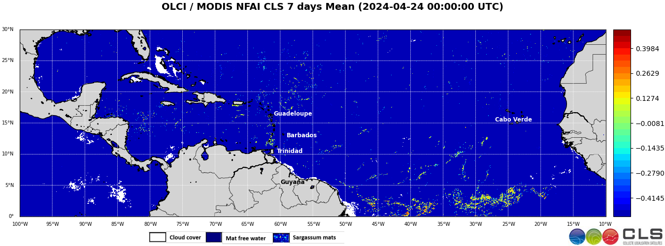
Latest Weekly Image over the Atlantic
Weekly average of the 300-m resolution CLS NFAI Sargassum Index combining Sentinel-3/OLCI and Aqua/MODIS optical sensors. Dark blue shows waters without any Sargassum detection. Green to Red show sargassum presence over one week. White shows remaining cloud cover.
