
CLS begins developments for oceanic drift models on NextGEOSS datahub
- 2 July 2019
- Category: Value-added services

Many societal challenges listed in the UN Sustainable Development goals can be addressed by greater access to Earth Observations (EO) from satellites. Yet, today access to this wealth of data is difficult for the uninitiated user. To facilitate exchanges between end-users and data providers, the European Commission has provided H2020 funding to develop a European data hub called NextGEOSS, and CLS, a leading satellite-services provider, will provide cloud-based access to its oceanic drift model within this project.
Space-based data for developers worldwide
NextGEOSS is a European data hub designed to facilitate access to the huge amounts of data that are available from Europe’s Copernicus program. Developed within a consortium of European company’s led by Deimos, NextGEOSS provides one stop shopping for Earth Observation (EO) data from Sentinel satellites and provides a collaborative, standardized ecosystem for developers. End-users are involved in the development process and drive the output.
CLS to provide oceanic drift modelling
Within this project, CLS is leading a pilot on ocean drift models, based on an expertise in drift modelling that CLS has developed over the past 10 years.
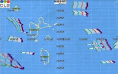
The CLS suite of drift models, Mobidrift, is a global, 2D drift model with real-time, archive or forecasting capabilities. It embeds several algorithms that make it possible to estimate the drift of specific objects in four different modes: icebergs, containers, Search & Rescue and a standard 2D Lagrangian particles mode to simulate the drift of oil spills, marine litter or algae patches at the surface. Mobidrift offers an ensemble mode (Monte-Carlo algorithm) which allows a probabilistic approach to the drift modeling.
It uses Earth observation data such as sea surface temperature, wind field, surface current, tidal current and bathymetry as input. In the frame of NextGEOSS, Mobidrift will retrieve the EO inputs from Copernicus Marine Environment Monitoring Service (CMEMS) and CLS Datastore.
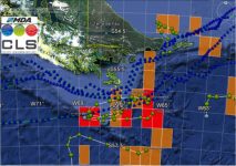
A key decision-making tool, the CLS drift model has already provided reliable results for a number of operational applications, including iceberg forecasting for ocean races, sargassum forecasting for public authorities and the tourist industry in the Caribbean, and oil spill drift forecasting for the European Maritime Safety Agency (EMSA) as well as the oil & gas industry.
Cloud-based infrastructure to maximize end-users
Within NextGEOSS, CLS will benefit from the Cloud integration service, which provides tools to build, test and deploy Mobidrift in a scalable cloud infrastructure.
These developments will ensure that the drift model is available to a large user community and increase the number of end-users for the drift services.
Oceanic drift model pilot project
NextGEOSS provides the framework for CLS to operate a pilot project to test the forecasting service.
On the CLS web platform, end users will select the type of object whose drift they want to forecast (such as a container, plastic pollution, oil slick, or sargassum algae), then they will select different entries to initiate the simulation (object position and date, Monte-Carlo ensemble mode, etc).
The CLS drift model, hosted on the NextGEOSS cloud, will be activated and will complete the simulation to forecast the object’s next positions.
Join us, test our model!
A number of societal challenges can be addressed with our drift model, including tracking plastics in the ocean or forecasting the drift of oil pollution. A number of operational applications can also be addressed, such as finding containers. Please contact us if you are interested in participating in the pilot project.
Key links:
Project page : https://nextgeoss.eu/pilots/
Video: https://www.youtube.com/watch?v=uJdE8cEqwHY